Built for every part of the journey, this extra big, extra rugged all-terrain navigator has the mapping you need to stay on track and communication technology to stay in touch while you’re out there.
10” All-Terrain Navigator
OFF-ROAD RUGGEDNESS
Purpose-built for all-terrain use, this Tread device stands up to anything the elements can throw at it. It’s IP67-rated for water-resistance.
HIGH-VISIBILITY DISPLAY
With its ultrabright 10” glove-friendly touchscreen, the navigator is designed for easy viewing in bright sunlight or pitch dark. It can be mounted in portrait or landscape mode.
TRAIL NAVIGATION
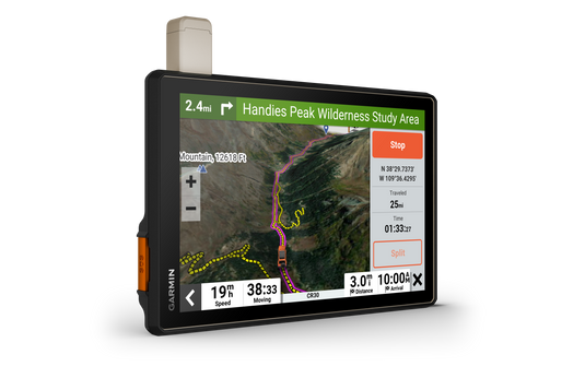
Enjoy turn-by-turn trail navigation for traversing unpaved roads and trails using adventure roads and trails map content comprised of OSM and USFS Motor Vehicle Use Maps.
BUILT-IN INREACH TECHNOLOGY
Built-in inReach technology offers global satellite communication3, two-way text messaging, location sharing and interactive SOS (active satellite subscription required).
MAPS ON AND OFF-ROAD
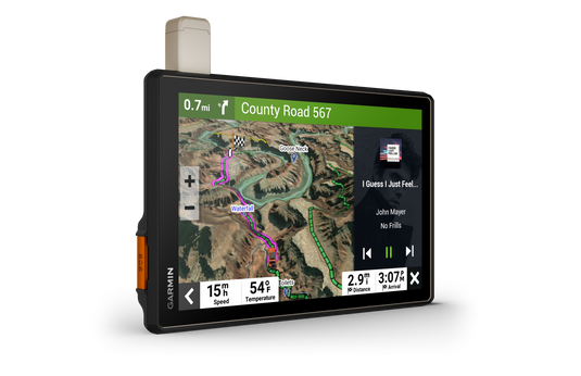
Tread includes preloaded topographic maps with 3D terrain for North and South America. It also includes detailed street maps of North America with custom routing for the size and weight of your rig2.
KNOW YOUR BOUNDARIES
Access U.S. public land boundaries for national forests, Bureau of Land Management (BLM), wilderness areas and more. Also, see U.S. private land boundaries and landowner information for parcels greater than 4 acres.
SATELLITE IMAGERY
Enjoy vivid aerial views when you download high-resolution BirdsEye Direct Satellite Imagery directly to your device via Wi-Fi® connectivity, with no annual subscription required.
TRAIL RATINGS
Our growing trail database now includes difficulty ratings for off-road riding areas, where available, across the U.S.
SNOWMOBILE TRAILS
View snowmobile trail content for select areas within the U.S. and in Canadian provinces. This includes snowmobile-accessible locations such as fuel stops, warming shelters, restaurants and more.
OUTDOOR MAPS+
With a paid Outdoor Maps+ subscription, you’ll get ongoing access to a wide variety of additional premium map content. It is regularly updated and delivered directly to your Tread device via Wi-Fi® connectivity.